
, Explains Strategic Business Development")


What’s the latest on the hurricane?published at 07:21 GMT
Elizabeth Rizzini
Lead weather presenter

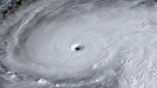
A satellite view shows Tropical Storm Melissa over the Caribbean Sea
The eye wall is still to the south of Jamaica and much of the island is already under tropical storm conditions.
The storm is very slow moving at only 2mph (3.2km/h) in a north-easterly direction. Now that it has turned northwards, it could speed up a little.
The current sustained wind speeds are 175mph (282km/h) with higher gusts. It is an extremely dangerous category five hurricane. It’s the strongest storm on Earth so far this year in terms of wind speeds and central pressure, which is currently just 901 millibars.
Landfall is expected later today in Jamaica and catastrophic and life-threatening hurricane-force winds are expected to begin this morning.
There will be another 15 to 30 inches of rainfall for Jamaica with a storm surge of up to 13ft near landfall on the south coast with large and destructive waves. On the north-west coast, near Montego Bay, there could be a 2ft to 4ft storm surge. We are expecting landslides and catastrophic flooding.
For Haiti, tropical storm conditions will begin later today too, with 6-12in of rainfall.
The storm will move northwards very slowly bringing further rain and will then make landfall again in south-eastern Cuba, still as a major hurricane.
Swells generated by Melissa are expected to affect portions of Hispaniola, Jamaica, eastern Cuba, and the Cayman Islands during the next several days, likely causing life-threatening surf and rip current conditions.
These swells will reach the Bahamas, the Turks and Caicos Islands, and Bermuda later this week.


